Metro Detroit, Michigan Weather: “A Cool Tuesday Night ahead of mid-week warm-up!”
DETROIT- Good Tuesday evening, Metro Detroit!
After both a cloudy and cool last couple of days around Metro Detroit, we finally will bust into a little bit of sunshine which will allow temperatures to rise quite a bit beginning tomorrow! But first, let’s talk about both the here and now, shall we?!
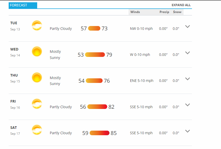
Alrighty! So this evening, we will have both partly cloudy skies and cool conditions too around Metro Detroit along with both temperatures in the upper 60s to low 70s before sunset, and then, in the upper 60s afterwards, and light winds WNW at only 5-10 mph drawing in both cool and comfortable Canadian air that we love so much around here!
Sunset tonight is at 7:47 p.m. ET.
Then, overnight tonight, we will have both mostly clear skies and cool conditions too around Metro Detroit along with both overnight low temperatures dropping down into the upper 50s in our Metro Zone or our Urban Heat Island, but likely dropping down into the middle 50s outside of our Urban Heat Island in our typically cooler rural areas, as WDIV’s or Local 4 News’ meteorologist Paul Gross likes to say, and light winds WNW at only 5-10 mph still drawing in both cool and comfortable Canadian air that we love so much around here! So, tonight will definitely be windows both up and open kind of night if both you and your family are comfortable with that, of course!
Sunrise tomorrow on your “Hump Day”, or Wednesday, is at 7:12 a.m. ET.
MILD HUMP DAY:
Your Wednesday morning will feature both mostly clear skies and cool conditions too around Metro Detroit as we both get up and get going for either work, for the parents, or for school, for the kids, to morning low temperatures in the middle-to-upper 50s. But thankfully, the afternoon should warm up under mostly sunny skies around all of Metro Detroit along with both daytime high temperatures flirting with 80F and light winds WNW at only 5-10 mph still continuing to bring in both cool and comfortable Canadian air that we love so much around here!
Mostly clear skies and cool once again around Metro Detroit Wednesday night along with both overnight low temperatures dipping down into the middle 50s (so, double-nickels) and light winds NW at only 5-10 mph still continuing to bring in both cool and comfortable Canadian air that we love so much around here!
THE REST OF THIS WEEK:
Mostly sunny skies once again on your Thursday around Metro Detroit along with both daytime high temperatures dipping down into the upper 70s and light winds ENE at only 5-10 mph which means that both east-siders and our Thumb area will be slightly cooler as those winds will be blowing off of both Lakes Huron and St. Clair.
Mostly clear skies and cool once again around Metro Detroit Thursday night along with overnight low temperatures flirting with 60F.
Partly cloudy skies and a notch warmer too around Metro Detroit on our “Finally Friday” as we wrap up both this work and this school week along with daytime high temperatures rising into the low 80s.
Partly cloudy skies and not as cool as Thursday night on Friday night along with overnight low temperatures in the low 60s.
A DRY WEEKEND AHEAD:
Partly cloudy skies and heating up both weekend days on our Saturday and on our Sunday around Metro Detroit along with daytime high temperatures rising into the middle 80s on Saturday, but in the upper 80s on Sunday.
HEATING UP BIG-TIME NEXT WEEK AS SUMMER 2022 WINDS DOWN:
Dry all of next week around Metro Detroit along with daytime high temperatures in the upper 80s on next Monday, but soaring into the low-to-middle 90s next Tuesday through next Thursday. So, please stay tuned!
Your donation will support the student journalists of Dakota High School. Your contribution will allow us to purchase equipment and cover our annual website hosting costs.

Zachary Veal is a senior at Dakota High School. He is interested in music while playing percussion in his 3rd hour Concert Band class right here at Dakota,...